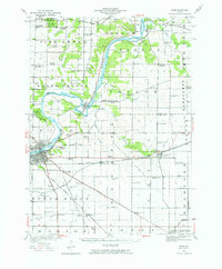
1950 Map of Dixon
USGS Topo · Published 1976About this map
The Rock River carves a winding path through this landscape, creating a dramatic oxbow around the village of Grand Detour. In 1950, this area of Ogle and Lee counties remained a patchwork of productive agricultural tracts and rural educational outposts, connected by the Chicago and Northwestern and Illinois Central railroads. The map reveals the civic fabric of the era through a dense distribution of country schoolhouses, including the Harmony Hill School, Tealls Corners School, and Samuel Dysant School, many of which served as local landmarks for generations of farming families.
Find a feature on this map
87 named features on this map. Tap any name to fly to it.
Don’t see what you’re looking for? This feature index may not catch every label — zoom into the map to look around manually.
Map Details
Editions of this 1950 Dixon Map
2 editions found

Other maps of this area

1917 · Kings
USGS Topo · 1:62,500

1918 · Dixon
USGS Topo · 1:62,500

1918 · Kings
USGS Topo · 1:62,500

1922 · Oregon
USGS Topo · 1:62,500

1924 · Oregon
USGS Topo · 1:62,500

1930 · Woodsung
USGS Topo · 1:48,000

1942 · Forreston
USGS Topo · 1:62,500

1945 · Forreston
USGS Topo · 1:62,500

1946 · Sterling
USGS Topo · 1:62,500

1948 · Sterling
USGS Topo · 1:62,500