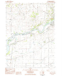
1983 Map of Dixon West
USGS Topo · Published 1984About this map
The Rock River carves a winding path through this portion of Lee County, serving as the central axis for a landscape defined by late-twentieth-century infrastructure and established rural communities. On the northern banks, Dixon extends toward Lincoln Heights, while the Hennepin Canal enters from the west, reflecting the area's legacy of water-based transport. The southern portion of the map is dominated by a grid of agricultural land and transit corridors, including the Illinois Tollway and the Chicago and North Western railway lines that converge near the village of Nelson. Local history is anchored by several cemeteries and churches, such as Pine Grove Cem and Sugar Grove Ch (Luth), which mark the long-standing centers of the Palmyra and Nelson townships. The presence of Sauk Valley College and Collins Airstrip illustrates the mid-century institutional and utility development of the Dixon area.
Find a feature on this map
44 named features on this map. Tap any name to fly to it.
Don’t see what you’re looking for? This feature index may not catch every label — zoom into the map to look around manually.
Map Details
Editions of this 1983 Dixon West Map
This is the sole edition of this map. No revisions or reprints were ever made.
Other maps of this area

1918 · Dixon
USGS Topo · 1:62,500

1930 · Woodsung
USGS Topo · 1:48,000

1946 · Sterling
USGS Topo · 1:62,500

1948 · Sterling
USGS Topo · 1:62,500

1949 · Walnut
USGS Topo · 1:62,500

1950 · Dixon
USGS Topo · 1:62,500

1951 · Amboy
USGS Topo · 1:62,500

1958 · Aurora
USGS Topo · 1:250,000

1961 · Aurora
USGS Topo · 1:250,000

1982 · Harmon
USGS Topo · 1:24,000