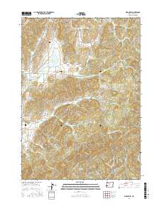
2017 Map of Dixonville
USGS Topo · Published 2017About this map
Dixonville serves as the primary hub in this Douglas County landscape, where the timber industry's footprint is visible through specialized features like the Dixonville Log Pond and Johnston Log Pond. The terrain is defined by the complex drainage of the Deer Creek system, including the N Fork Deer Cr and the Middle Fork of S Fork Deer Cr, which carve through the elevations near Black Mud Summit and Brushy Butte.
Find a feature on this map
68 named features on this map. Tap any name to fly to it.
Don’t see what you’re looking for? This feature index may not catch every label — zoom into the map to look around manually.
Map Details
Editions of this 2017 Dixonville Map
This is the sole edition of this map. No revisions or reprints were ever made.
Other maps of this area

1897 · Roseburg
USGS Topo · 1:125,000

1900 · Roseburg
USGS Topo · 1:125,000

1954 · Dixonville
USGS Topo · 1:62,500

1954 · Sutherlin
USGS Topo · 1:62,500

1954 · Glide
USGS Topo · 1:62,500

1955 · Roseburg
USGS Topo · 1:62,500

1958 · Roseburg
USGS Topo · 1:250,000

1959 · Roseburg
USGS Topo · 1:250,000

1979 · Roseburg
USGS Topo · 1:100,000
1987 · Roseburg East
USGS Topo · 1:24,000