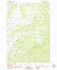
1987 Map of Dixonville
USGS Topo · Published 1987About this map
Dixonville serves as the primary settlement on this Douglas County landscape, situated where the North Fork Deer Creek and South Fork Deer Creek converge. The topography is defined by the drainage systems of the Deer Creek watershed, including Tucker Creek and Clover Creek, which carve through the elevations near Brushy Butte. Local history and land use are evidenced by a Mine and a Cem located in the southern sections, while the presence of O C Brown County Park indicates the area's role in regional recreation by the late 1980s. Small rural clusters like Melton are visible along the winding valley roads, illustrating the dispersed nature of habitation in this part of Oregon. The map also traces the headwaters of Lee Creek and N Myrtle Cr, providing a detailed view of the water network before it exits the quadrangle.
Find a feature on this map
17 named features on this map. Tap any name to fly to it.
Don’t see what you’re looking for? This feature index may not catch every label — zoom into the map to look around manually.
Map Details
Editions of this 1987 Dixonville Map
This is the sole edition of this map. No revisions or reprints were ever made.
Other maps of this area

1897 · Roseburg
USGS Topo · 1:125,000

1900 · Roseburg
USGS Topo · 1:125,000

1954 · Dixonville
USGS Topo · 1:62,500

1954 · Sutherlin
USGS Topo · 1:62,500

1954 · Glide
USGS Topo · 1:62,500

1955 · Roseburg
USGS Topo · 1:62,500

1958 · Roseburg
USGS Topo · 1:250,000

1959 · Roseburg
USGS Topo · 1:250,000

1979 · Roseburg
USGS Topo · 1:100,000
1987 · Roseburg East
USGS Topo · 1:24,000