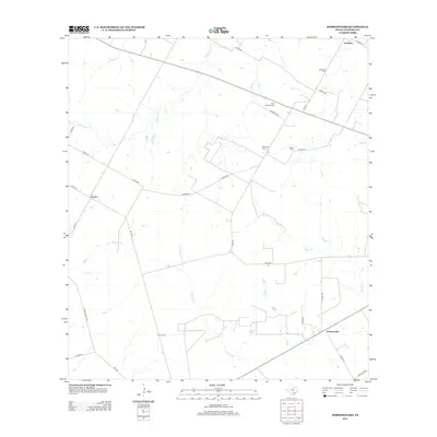
2012 Map of Dobrowolski
USGS Topo · Published 2012About this map
Rodriguez Cem and Saint Williams Cem anchor the north-central part of this South Texas landscape, reflecting the deep-rooted family histories of Atascosa County. The terrain is defined by a network of seasonal watercourses, including La Parita Cr and Santa Anna Cr, which dictate the placement of ranch roads and small settlements. Small communities like Dobrowolski and Amphion are interconnected by a web of county roads such as Gomez Rd and Mendiola Ln. The map reveals a rural economy based on large landholdings, where numerous private cemeteries like Mendiola Cem and Garcia Cem are situated far from main thoroughfares, providing a clear view of genealogical distribution across this brush-country territory. This 2012 survey illustrates how modern infrastructure like FM-2146 follows historical land divisions and natural drainages like Panther Cr.
Find a feature on this map
34 named features on this map. Tap any name to fly to it.
Don’t see what you’re looking for? This feature index may not catch every label — zoom into the map to look around manually.
Map Details
Editions of this 2012 Dobrowolski Map
This is the sole edition of this map. No revisions or reprints were ever made.
Other maps of this area

1934 · Schattel
USGS Topo · 1:62,500

1942 · Natalia
USGS Topo · 1:62,500

1953 · Crystal City
USGS Topo · 1:250,000

1954 · San Antonio
USGS Topo · 1:250,000

1955 · Crystal City
USGS Topo · 1:250,000

1956 · Jourdanton
USGS Topo · 1:62,500

1957 · San Antonio
USGS Topo · 1:250,000

1961 · Crystal City
USGS Topo · 1:250,000
1964 · Bigfoot
USGS Topo · 1:24,000

1968 · Crystal City
USGS Topo · 1:250,000