
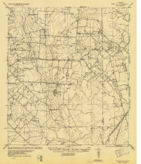
1934 Map of Schattel
USGS Topo · Published 1940About this map
The San Antonio Uvalde and Gulf RR (Mo Pac) cuts across the southeast corner of this Frio County landscape, illustrating the regional reliance on rail for cattle and agricultural transport in the early 1930s. Small, centralized nodes of rural life appear at Schattel, Thomson, and Miguel, while the presence of Sand Hollow School, Fisher School, and Shallow Wells School suggests a community structure built around widely spaced country school districts. The terrain is defined by the drainage systems of San Miguel Creek and Chiltipin Creek, which carve through the Marshall Hills. Large livestock operations like Keystone Ranch and Goat Ranch anchor the economy, supported by vital water infrastructure such as several Artesian Wells and Howard Lake.
Find a feature on this map
33 named features on this map. Tap any name to fly to it.
Don’t see what you’re looking for? This feature index may not catch every label — zoom into the map to look around manually.
Map Details
Editions of this 1934 Schattel Map
2 editions found
Other maps of this area

1927 · Pearsall
USGS Topo · 1:62,500

1942 · Dilley
USGS Topo · 1:62,500

1942 · Natalia
USGS Topo · 1:62,500

1953 · Crystal City
USGS Topo · 1:250,000

1954 · San Antonio
USGS Topo · 1:250,000

1955 · Crystal City
USGS Topo · 1:250,000

1956 · Jourdanton
USGS Topo · 1:62,500

1956 · Hindes
USGS Topo · 1:62,500

1956 · Franklin Settlement
USGS Topo · 1:62,500

1957 · San Antonio
USGS Topo · 1:250,000