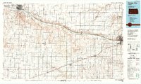
1985 Map of Dodge City
USGS Topo · Published 1988About this map
The Arkansas River corridor serves as the primary axis of settlement across this mid-1980s landscape, connecting the significant regional hubs of Dodge City and Garden City. Following the southern bank of the river, the Atchison Topeka and Santa Fe railroad line defines the transportation network of the era, linking smaller agricultural and railway outposts like Pierceville, Ingalls, and Cimarron. The survey reveals a region shaped by both the natural drainage of Sawlog Creek and Mulberry Creek and the industrial footprint of expansive gas fields that dominate the western townships. Rural life is anchored by dispersed communities such as Gray Center, Montezuma, and Copeland, while aviation infrastructure at Garden City Municipal Airport and smaller municipal strips indicate the growing logistical importance of these High Plains centers during the late twentieth century.
Find a feature on this map
53 named features on this map. Tap any name to fly to it.
Don’t see what you’re looking for? This feature index may not catch every label — zoom into the map to look around manually.
Map Details
Editions of this 1985 Dodge City Map
2 editions found
Other maps of this area

1891 · Larned
USGS Topo · 1:125,000

1892 · Ness
USGS Topo · 1:125,000

1892 · Meade
USGS Topo · 1:125,000

1892 · Dodge
USGS Topo · 1:125,000

1892 · Spearville
USGS Topo · 1:125,000

1894 · Spearville
USGS Topo · 1:125,000

1894 · Ness
USGS Topo · 1:125,000

1896 · Garden
USGS Topo · 1:125,000

1896 · Ashland
USGS Topo · 1:125,000

1900 · Lakin
USGS Topo · 1:125,000