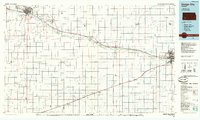
1985 Map of Dodge City
USGS Topo · Published 1985About this map
The Arkansas River corridor serves as the primary axis of development across this 1985 planimetric survey, following the historic path of the Atchison Topeka and Santa Fe railroad. In the western reaches, Garden City and Holcomb anchor a landscape defined by industrial activity and conservation, including the Finney County State Game Refuge. Further east, Dodge City and South Dodge appear as the region's major hubs, featuring institutional landmarks such as St Mary of the Plains College and Dodge City Community College. The map captures the specialized agricultural and extractive economy of Southwest Kansas, highlighting a vast gas field and sites like the Silica Pit. Smaller grain and rail outposts including Cimarron, Montezuma, and Copeland dot the plains, connected by the iron rail lines and the drainage systems of Sawlog Creek and Crooked Creek.
Find a feature on this map
39 named features on this map. Tap any name to fly to it.
Don’t see what you’re looking for? This feature index may not catch every label — zoom into the map to look around manually.
Map Details
Editions of this 1985 Dodge City Map
2 editions found
Other maps of this area

1891 · Larned
USGS Topo · 1:125,000

1892 · Ness
USGS Topo · 1:125,000

1892 · Meade
USGS Topo · 1:125,000

1892 · Dodge
USGS Topo · 1:125,000

1892 · Spearville
USGS Topo · 1:125,000

1894 · Spearville
USGS Topo · 1:125,000

1894 · Ness
USGS Topo · 1:125,000

1896 · Garden
USGS Topo · 1:125,000

1896 · Ashland
USGS Topo · 1:125,000

1900 · Lakin
USGS Topo · 1:125,000