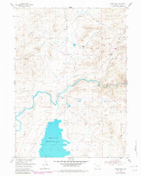
1955 Map of Dodge Ranch
USGS Topo · Published 1982About this map
Wheatland Reservoir No 2 dominates the southern portion of this high-plains landscape in Albany County, Wyoming. Surveyed in the mid-1950s and updated with late-1970s aerial data, the map details a region defined by its water management and cattle ranching history. The Laramie River carves a winding path across the center of the sheet, supported by a network of infrastructure including a gaging station, irrigation ditches, and a prominent tunnel and pipeline system designed to move water through the arid terrain.
Find a feature on this map
18 named features on this map. Tap any name to fly to it.
Don’t see what you’re looking for? This feature index may not catch every label — zoom into the map to look around manually.
Map Details
Editions of this 1955 Dodge Ranch Map
2 editions found
Other maps of this area

1954 · Torrington
USGS Topo · 1:250,000

1954 · Cheyenne
USGS Topo · 1:250,000

1955 · Mc Gill Lakes
USGS Topo · 1:24,000

1955 · Dodge Ranch
USGS Topo · 1:24,000

1955 · Bluegrass Wells
USGS Topo · 1:24,000

1955 · Ayres Spring
USGS Topo · 1:24,000

1955 · Guide Rock
USGS Topo · 1:24,000

1955 · Bull Camp Peak
USGS Topo · 1:24,000

1958 · Cheyenne
USGS Topo · 1:250,000

1958 · Torrington
USGS Topo · 1:250,000