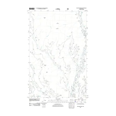
2011 Map of Doe Mountain
USGS Topo · Published 2011About this map
The Chewuch River valley serves as the central corridor for this backcountry region of the Okanogan-Wenatchee National Forest. Several recreational hubs are established along this waterway, including Camp Four Campground and Chewuch Campground, which provide access to the surrounding peaks. High-elevation landmarks such as Doe Mountain, Farewell Peak, and Paul Mountain define the drainage basins for numerous creeks, including Eightmile Creek and Falls Creek. Near the river, Siegels Slough and Nice Campground offer specialized riverside environments, while the drainage to the west is dominated by the steep profile of Eightmile Ridge. The map documents a landscape defined by forest service access and remote natural features like Falls Creek Falls, illustrating the region's role as a protected wilderness and recreation area in the early 21st century.
Find a feature on this map
29 named features on this map. Tap any name to fly to it.
Don’t see what you’re looking for? This feature index may not catch every label — zoom into the map to look around manually.
Map Details
Editions of this 2011 Doe Mountain Map
This is the sole edition of this map. No revisions or reprints were ever made.
Other maps of this area

1955 · Concrete
USGS Topo · 1:250,000

1958 · Concrete
USGS Topo · 1:250,000

1962 · Concrete
USGS Topo · 1:250,000

1962 · Mazama
USGS Topo · 1:62,500

1963 · Doe Mountain
USGS Topo · 1:62,500

1969 · Mt. Barney
USGS Topo · 1:24,000

1969 · Billy Goat Mtn
USGS Topo · 1:24,000
1969 · Coleman Peak
USGS Topo · 1:24,000
1991 · Rendevous Mountain
USGS Topo · 1:24,000
1991 · Sweetgrass Butte
USGS Topo · 1:24,000