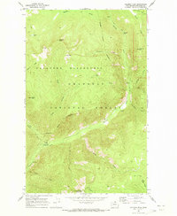
1969 Map of Coleman Peak
USGS Topo · Published 1973About this map
Pasayten Wilderness and the Okanogan National Forest dominate this 1969 topographic study, where the Chewack River carves through high terrain. The map documents a landscape defined by seasonal access and remote landmarks, notably the Lookout Tower atop Twentymile Pk and the established riverfront sites at Thirtymile Campground and Andrews Creek Campground. A network of historic routes, including the Andrews Pack Trail, follows the watercourses, linking high-altitude water bodies like Tonseth Lake and Meadow Lake. High points such as Coleman Peak and Thirtymile Peak provide critical reference for the remote interior of the North Cascades. The map effectively captures the infrastructure of the wilderness during the late 1960s, from the Chewack Falls to the various corrals and benchmarks that once supported backcountry travelers and forest rangers.
Find a feature on this map
38 named features on this map. Tap any name to fly to it.
Don’t see what you’re looking for? This feature index may not catch every label — zoom into the map to look around manually.
Map Details
Editions of this 1969 Coleman Peak Map
This is the sole edition of this map. No revisions or reprints were ever made.
Other maps of this area

1906 · Chopaka
USGS Topo · 1:125,000

1954 · Okanogan
USGS Topo · 1:250,000

1955 · Concrete
USGS Topo · 1:250,000

1956 · Tiffany Mountain
USGS Topo · 1:62,500

1956 · Horseshoe Basin
USGS Topo · 1:62,500

1958 · Concrete
USGS Topo · 1:250,000

1958 · Okanogan
USGS Topo · 1:250,000

1962 · Concrete
USGS Topo · 1:250,000

1963 · Doe Mountain
USGS Topo · 1:62,500

1969 · Mt. Barney
USGS Topo · 1:24,000