
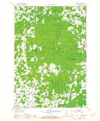
1951 Map of Doering
USGS Topo · Published 1954About this map
The Pine River and Eau Claire River systems carve through this rural Northwoods landscape at the junction of Lincoln, Langlade, and Marathon counties. Small rural centers like Doering and Hogarty serve as anchors for a dispersed farming and timber community. The density of country schoolhouses, such as Doering Sch, McMynn Sch, and Sunrise Sch, reflects a mid-century social structure where education was decentralized and locally managed.
Find a feature on this map
61 named features on this map. Tap any name to fly to it.
Don’t see what you’re looking for? This feature index may not catch every label — zoom into the map to look around manually.
Map Details
Editions of this 1951 Doering Map
2 editions found
Other maps of this area

1899 · Wausau
USGS Topo · 1:125,000

1902 · Wausau
USGS Topo · 1:125,000

1940 · Parrish
USGS Topo · 1:48,000

1942 · Elcho
USGS Topo · 1:48,000

1950 · Elcho
USGS Topo · 1:48,000

1950 · Parrish
USGS Topo · 1:48,000

1950 · Tomahawk
USGS Topo · 1:48,000

1951 · Merrill
USGS Topo · 1:48,000

1952 · Parrish
USGS Topo · 1:48,000

1952 · Tomahawk
USGS Topo · 1:48,000