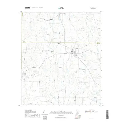
2020 Map of Doerun
USGS Topo · Published 2020About this map
Doerun serves as the central hub of this agricultural landscape in Colquitt County, where a grid of rural roads connects the surrounding settlements of Minnesota, Ticknor, and Pritchetts. The terrain is defined by the gentle drainage of the Ochlockonee River on the eastern edge and several smaller tributaries like Bridge Cr and Brushy Br that move through the lowlands. This area is particularly rich for family history research, as it preserves the locations of numerous small burial grounds including Liberty Hill Cem, Union Cem, and the Cool Springs Baptist Church Cem. The map illustrates a classic South Georgia pattern of scattered farmsteads and rural crossroads, with named landmarks like Sanders Lake and Sells Lake serving as prominent water features among the tilled fields and timber stands that characterize the region's 21st-century topography.
Find a feature on this map
81 named features on this map. Tap any name to fly to it.
Don’t see what you’re looking for? This feature index may not catch every label — zoom into the map to look around manually.
Map Details
Editions of this 2020 Doerun Map
This is the sole edition of this map. No revisions or reprints were ever made.
Other maps of this area

1953 · Dothan
USGS Topo · 1:250,000

1953 · Waycross
USGS Topo · 1:250,000

1954 · Dothan
USGS Topo · 1:250,000

1955 · Dothan
USGS Topo · 1:250,000

1956 · Baconton
USGS Topo · 1:62,500

1956 · Doerun
USGS Topo · 1:62,500

1958 · Waycross
USGS Topo · 1:250,000

1971 · Cotton
USGS Topo · 1:24,000
1974 · Putney
USGS Topo · 1:24,000
1974 · Doerun
USGS Topo · 1:24,000