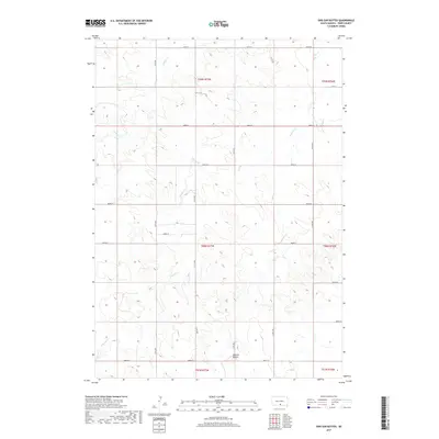
2017 Map of Dog Ear Buttes
USGS Topo · Published 2017About this map
Dog Ear Buttes rise as a prominent topographic landmark in this section of South Dakota, anchoring a landscape defined by the drainage patterns of Dog Ear Cr and Hollow Cr. The map reveals a strictly regulated prairie landscape, where the public land survey system has dictated a precise grid of rural transport, including routes like 280th St and 311th Ave. This late-period survey illustrates how modern infrastructure in Tripp County remains closely tied to the underlying terrain and watershed boundaries, such as the small drainage of Mud Cr in the northeast. The absence of concentrated town centers emphasizes the expansive, ranch-and-farm character of the Ideal segment, where geographic features like the buttes serve as the primary navigational anchors for the surrounding rural sections.
Find a feature on this map
24 named features on this map. Tap any name to fly to it.
Don’t see what you’re looking for? This feature index may not catch every label — zoom into the map to look around manually.
Map Details
Editions of this 2017 Dog Ear Buttes Map
This is the sole edition of this map. No revisions or reprints were ever made.
Other maps of this area

1955 · Martin
USGS Topo · 1:250,000

1955 · Mitchell
USGS Topo · 1:250,000

1958 · Martin
USGS Topo · 1:250,000

1959 · Mitchell
USGS Topo · 1:250,000

1982 · Winner North
USGS Topo · 1:25,000

1982 · Witten SE
USGS Topo · 1:25,000

1982 · Witten
USGS Topo · 1:25,000

1982 · Winner South
USGS Topo · 1:25,000
1982 · Miller Hill
USGS Topo · 1:25,000
1982 · Wewela NE
USGS Topo · 1:24,000