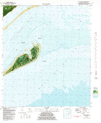
1982 Map of Dog Island
USGS Topo · Published 1982About this map
Dog Island serves as the focal point of this 1982 orthophotomap, showing the barrier island's vegetation and shifting sands during the early 1980s. This hybrid topographic-bathymetric study captures the complex maritime environment where Saint George Sound meets the Gulf of Mexico. On the island's northern shore, Tysons Harbor provides a sheltered inlet, while the surrounding waters are defined by hazards such as Lanark Reef and the extensive Dog Island Reef. A notable Ferry route is indicated, connecting the island to the mainland across the sound. Frequent shoreline shifts are explicitly noted as an area subject to frequent change, reflecting the dynamic nature of these coastal landforms before subsequent decades of storm-driven erosion and deposition further altered the landscape.
Find a feature on this map
9 named features on this map. Tap any name to fly to it.
Don’t see what you’re looking for? This feature index may not catch every label — zoom into the map to look around manually.
Map Details
Editions of this 1982 Dog Island Map
2 editions found
Other maps of this area

1943 · Dog Island
USGS Topo · 1:31,680

1943 · Carrabelle
USGS Topo · 1:24,000

1943 · St. Teresa Beach
USGS Topo · 1:24,000

1944 · Pickett Bay
USGS Topo · 1:31,680

1944 · Carrabelle
USGS Topo · 1:31,680

1944 · Sugar Hill
USGS Topo · 1:31,680

1945 · Mc Intyre
USGS Topo · 1:31,680

1945 · Sugar Hill
USGS Topo · 1:31,680

1945 · St Teresa
USGS Topo · 1:31,680

1945 · Pickett Bay
USGS Topo · 1:31,680