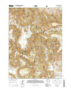
2014 Map of Dog Lake
USGS Topo · Published 2014About this map
Dog Lake and its surrounding watershed define this high-country landscape within the Fremont National Forest. The map documents a terrain defined by complex hydrology, where numerous named water sources like Scotts Cabin Spring, Nick Barry Spring, and Dog Lake Burn Spring feed into systems like Dog Mountain Creek and Saghen Creek. This concentration of springs indicates the critical role of water management in the arid interior of Lake County.
Find a feature on this map
50 named features on this map. Tap any name to fly to it.
Don’t see what you’re looking for? This feature index may not catch every label — zoom into the map to look around manually.
Map Details
Editions of this 2014 Dog Lake Map
This is the sole edition of this map. No revisions or reprints were ever made.
Other maps of this area

1886 · Alturas
USGS Topo · 1:250,000

1892 · Alturas
USGS Topo · 1:250,000

1954 · Alturas
USGS Topo · 1:250,000

1955 · Klamath Falls
USGS Topo · 1:250,000

1958 · Alturas
USGS Topo · 1:250,000

1958 · Klamath Falls
USGS Topo · 1:250,000

1960 · Strawberry Butte
USGS Topo · 1:62,500

1962 · Alturas
USGS Topo · 1:250,000

1962 · Steele Swamp
USGS Topo · 1:62,500

1962 · South Mountain
USGS Topo · 1:62,500