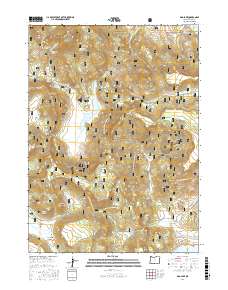
2017 Map of Dog Lake
USGS Topo · Published 2017About this map
Fremont National Forest defines this high-elevation landscape in Lake County, where complex hydrological systems and volcanic terrain converge. The central feature, Dog Lake, is fed by several drainages including Dog Mountain Cr and Dog Cr, illustrating the vital role of seasonal and permanent water sources in this arid region. The map reveals a dense network of forest development roads, such as Natl Forest Develop Road 401 Rd, which provide access to numerous springs like Little Dog Spring and Nick Barry Spring. These named springs and the proximity of the Drews Reservoir in the northeast corner suggest a history of resource management and livestock grazing. Low-lying areas like Young Valley and Green Valley are contrasted by prominent landmarks such as Dog Mtn and Castle Rock, while labels like Scotts Cabin Spring hint at early human presence and homesteading attempts in the rugged backcountry.
Find a feature on this map
52 named features on this map. Tap any name to fly to it.
Don’t see what you’re looking for? This feature index may not catch every label — zoom into the map to look around manually.
Map Details
Editions of this 2017 Dog Lake Map
This is the sole edition of this map. No revisions or reprints were ever made.
Other maps of this area

1886 · Alturas
USGS Topo · 1:250,000

1892 · Alturas
USGS Topo · 1:250,000

1954 · Alturas
USGS Topo · 1:250,000

1955 · Klamath Falls
USGS Topo · 1:250,000

1958 · Alturas
USGS Topo · 1:250,000

1958 · Klamath Falls
USGS Topo · 1:250,000

1960 · Strawberry Butte
USGS Topo · 1:62,500

1962 · Alturas
USGS Topo · 1:250,000

1962 · Steele Swamp
USGS Topo · 1:62,500

1962 · South Mountain
USGS Topo · 1:62,500