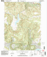
2004 Map of Dog Lake
USGS Topo · Published 2007About this map
Dog Lake sits at the heart of this high-elevation landscape within the Fremont National Forest, serving as a focal point for local hydrology and management. The Dog Lake Work Center and a nearby Boat Ramp indicate the area's role as a hub for forest service operations and recreation in the early 21st century. The map reveals a complex network of springs and drainages, such as Scotts Cabin Spring, Big Dog Spring, and Nick Barry Spring, which feed into the larger water systems of Drews Res and Renner Lake.
Find a feature on this map
38 named features on this map. Tap any name to fly to it.
Don’t see what you’re looking for? This feature index may not catch every label — zoom into the map to look around manually.
Map Details
Editions of this 2004 Dog Lake Map
This is the sole edition of this map. No revisions or reprints were ever made.
Other maps of this area

1886 · Alturas
USGS Topo · 1:250,000

1892 · Alturas
USGS Topo · 1:250,000

1954 · Alturas
USGS Topo · 1:250,000

1955 · Klamath Falls
USGS Topo · 1:250,000

1958 · Alturas
USGS Topo · 1:250,000

1958 · Klamath Falls
USGS Topo · 1:250,000

1960 · Strawberry Butte
USGS Topo · 1:62,500

1962 · Alturas
USGS Topo · 1:250,000

1962 · Steele Swamp
USGS Topo · 1:62,500

1962 · South Mountain
USGS Topo · 1:62,500