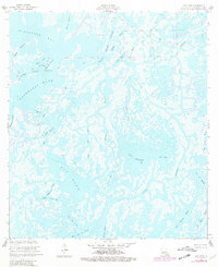
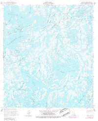
1953 Map of Dog Lake
USGS Topo · Published 1981About this map
The intricate coastal marshlands of Terrebonne Parish are defined here by a dense network of tidal channels and large open basins like Dog Lake and Hackberry Lake. This landscape is primarily shaped by the intersection of natural hydrology and industrial activity, most notably within the Four Isle Bayou Oil and Gas Field. The map reveals how petroleum extraction infrastructure began to weave through the wetlands, with a Radio Tower standing as a solitary landmark among the winding waterways of Grand Caillou Bayou and Quitman Bayou. Local nomenclature like Bayou John Bop and Chine Island reflects the specific cultural geography of this amphibious region. The intricate pass system, including Pass des Ilettes and Petit Pass des Ilettes, demonstrates the complex drainage patterns before significant late-century coastal erosion altered these shorelines.
Find a feature on this map
31 named features on this map. Tap any name to fly to it.
Don’t see what you’re looking for? This feature index may not catch every label — zoom into the map to look around manually.
Map Details
Editions of this 1953 Dog Lake Map
5 editions found
Other maps of this area

1894 · Bayou De Large
USGS Topo · 1:62,500

1894 · Dulac
USGS Topo · 1:62,500

1935 · Cocodrie
USGS Topo · 1:31,680

1935 · Lake Mechant
USGS Topo · 1:31,680

1935 · Lake Quitman
USGS Topo · 1:31,680

1940 · Bayou Du Large
USGS Topo · 1:62,500

1941 · Bayou Du Large
USGS Topo · 1:62,500

1941 · Dulac
USGS Topo · 1:62,500
1944 · Dulac
USGS Topo · 1:62,500

1944 · Bayou Du Large
USGS Topo · 1:62,500