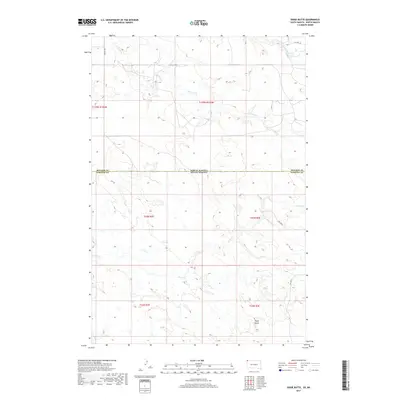
2017 Map of Dogie Butte
USGS Topo · Published 2017About this map
The state line between North Dakota and South Dakota bisects this prairie landscape, where the drainage systems of Fivemile Cr and Arnett Cr carve deep patterns into the high plains. In the southern half of the quadrangle, Dogie Butte serves as a prominent navigational landmark above the headwaters of Dogie Cr. The map captures a moment of transition in Harding County, showing how modern energy infrastructure, represented by Oil Well Rd, has been overlaid upon the traditional ranching landscape. Sections of the public land survey system are clearly delineated, tracing the boundaries of t23n r2e and t23n r3e. This 2017 survey reflects a sparsely populated area where named roads like Miller Pl and 99th St Sw provide the primary human skeleton for a terrain dominated by seasonal creek beds and geographic rises.
Find a feature on this map
17 named features on this map. Tap any name to fly to it.
Don’t see what you’re looking for? This feature index may not catch every label — zoom into the map to look around manually.
Map Details
Editions of this 2017 Dogie Butte Map
This is the sole edition of this map. No revisions or reprints were ever made.
Other maps of this area

1935 · Buffalo
USGS Topo · 1:125,000

1953 · Dickinson
USGS Topo · 1:250,000

1954 · Lemmon
USGS Topo · 1:250,000

1957 · Dickinson
USGS Topo · 1:250,000

1957 · Lemmon
USGS Topo · 1:250,000

1969 · Table Mountain
USGS Topo · 1:24,000

1969 · Ladner
USGS Topo · 1:24,000

1973 · Camel Butte
USGS Topo · 1:24,000
1973 · Mud Buttes
USGS Topo · 1:24,000
1973 · Cedar Ridge
USGS Topo · 1:24,000