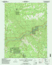
1994 Map of Dogwood Peak
USGS Topo · Published 1997About this map
Plumas National Forest dominates this landscape, where the Middle Fork Feather River carves a deep path through the Sierra Nevada. The terrain is defined by high-elevation landmarks like Dogwood Peak, Table Mountain, and Mount Hough, while the Pacific Crest National Scenic Trail traverses the eastern ridges near Fowler Lake. The map reveals the area's industrial history through scattered extraction sites, including the Little California Mine and Dejonah Creek Mine, situated along the steep drainages of Dejonah Creek and Carpenter Creek. These labels, alongside features like Hartman Bar Ridge and McFarland Ravine, reflect a century of mining activity and forest management. The integration of the Wild And Scenic River designation along the river corridor highlights the shift toward conservation and recreation in the late 20th century, evidenced by the presence of a Ranger Station and multiple Campsite locations.
Find a feature on this map
39 named features on this map. Tap any name to fly to it.
Don’t see what you’re looking for? This feature index may not catch every label — zoom into the map to look around manually.
Map Details
Editions of this 1994 Dogwood Peak Map
This is the sole edition of this map. No revisions or reprints were ever made.
Other maps of this area

1888 · Bidwell Bar
USGS Topo · 1:125,000

1891 · Bidwell Bar
USGS Topo · 1:125,000

1891 · Downieville
USGS Topo · 1:125,000

1893 · Bidwell Bar
USGS Topo · 1:125,000

1893 · Downieville
USGS Topo · 1:125,000

1895 · Bidwell Bar
USGS Topo · 1:125,000

1895 · Downieville
USGS Topo · 1:125,000

1896 · Downieville
USGS Topo · 1:125,000

1897 · Bidwell Bar
USGS Topo · 1:125,000

1897 · Downieville
USGS Topo · 1:125,000