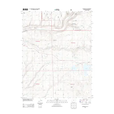
2013 Map of Dolores East
USGS Topo · Published 2013About this map
The Dolores River carves through the northern landscape of this region, serving as a primary corridor for both natural drainage and human activity. The town of Dolores sits at the western edge, where the canyon opens up and meets the higher plateau. To the south and east, an intricate network of irrigation systems including Summit Ditch, Camp Ditch, and Main Ditch feeds several significant water bodies like Summit Reservoir and Puett Reservoir. These waterworks highlight the agricultural development of the Montezuma County highlands, transforming the dry mesas into productive land.
Find a feature on this map
49 named features on this map. Tap any name to fly to it.
Don’t see what you’re looking for? This feature index may not catch every label — zoom into the map to look around manually.
Map Details
Editions of this 2013 Dolores East Map
This is the sole edition of this map. No revisions or reprints were ever made.
Other maps of this area

1956 · Cortez
USGS Topo · 1:250,000

1958 · Cortez
USGS Topo · 1:250,000

1959 · Cortez
USGS Topo · 1:250,000

1962 · Cortez
USGS Topo · 1:250,000

1963 · Stoner
USGS Topo · 1:24,000

1965 · Cortez
USGS Topo · 1:24,000

1965 · Dolores East
USGS Topo · 1:24,000

1965 · Dolores West
USGS Topo · 1:24,000
1965 · Millwood
USGS Topo · 1:24,000
1965 · Mancos
USGS Topo · 1:24,000