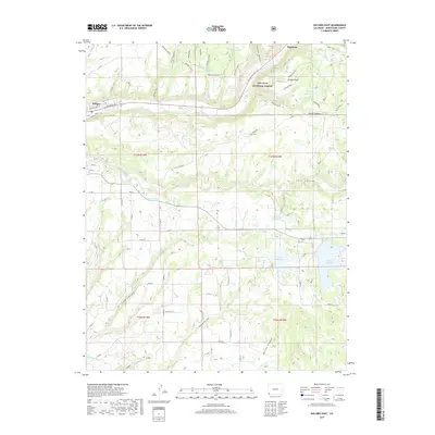
2019 Map of Dolores East
USGS Topo · Published 2019About this map
The Dolores River valley and the town of Dolores anchor this landscape in Montezuma County, where the historic path of the Rio Grande Southern RR still follows the river's bend. This 2019 survey captures a complex irrigation network essential to the high desert terrain, including the Summit Ditch, Camp Ditch, and S Main Ditch. These systems feed significant water bodies like Summit Reservoir and Puett Reservoir, which dominate the eastern portion of the quadrangle.
Find a feature on this map
85 named features on this map. Tap any name to fly to it.
Don’t see what you’re looking for? This feature index may not catch every label — zoom into the map to look around manually.
Map Details
Editions of this 2019 Dolores East Map
This is the sole edition of this map. No revisions or reprints were ever made.
Other maps of this area

1956 · Cortez
USGS Topo · 1:250,000

1958 · Cortez
USGS Topo · 1:250,000

1959 · Cortez
USGS Topo · 1:250,000

1962 · Cortez
USGS Topo · 1:250,000

1963 · Stoner
USGS Topo · 1:24,000

1965 · Cortez
USGS Topo · 1:24,000

1965 · Dolores East
USGS Topo · 1:24,000

1965 · Dolores West
USGS Topo · 1:24,000
1965 · Millwood
USGS Topo · 1:24,000
1965 · Mancos
USGS Topo · 1:24,000