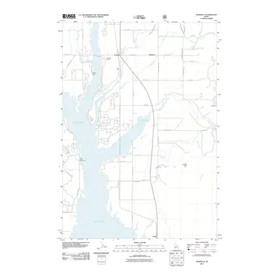
2011 Map of Donnelly
USGS Topo · Published 2011About this map
The settlement of Donnelly and the historic townsite of Roseberry anchor this landscape along the eastern shores of Lake Cascade. Modern infrastructure like the Donnelly Airport and Old State Hwy 15 intersects with a complex irrigation network of ditches and canals, including the Gold Fork Canal and Center Canal, which channel water from the Gold Fork River and Willow Creek. The terrain is shaped significantly by the reservoir, which flooded portions of the Long Valley in the mid-20th century, influencing the placement of recreational sites such as Poison Creek Campground and the Cascade Lake 4H Camp. Local water management is further evidenced by landmarks like Eld Dam and Koskella Dam, while the rural residential layout is defined by numerous named roads like Farm to Market Rd and Kaskella Rd.
Find a feature on this map
51 named features on this map. Tap any name to fly to it.
Don’t see what you’re looking for? This feature index may not catch every label — zoom into the map to look around manually.
Map Details
Editions of this 2011 Donnelly Map
This is the sole edition of this map. No revisions or reprints were ever made.
Other maps of this area

1911 · Meadows
USGS Topo · 1:125,000

1954 · Gold Fork
USGS Topo · 1:62,500

1954 · Cascade
USGS Topo · 1:62,500

1955 · Baker
USGS Topo · 1:250,000

1957 · Challis
USGS Topo · 1:250,000

1959 · Baker
USGS Topo · 1:250,000

1960 · Challis
USGS Topo · 1:250,000

1963 · Challis
USGS Topo · 1:250,000
1973 · No Business Mtn
USGS Topo · 1:24,000
1973 · Paddy Flat
USGS Topo · 1:24,000