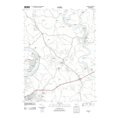
2010 Map of Donora
USGS Topo · Published 2010About this map
The Monongahela River and Youghiogheny River carve through this portion of Westmoreland and Washington Counties, defining the industrial and residential geography of the Mon Valley in the early 21st century. The city of Donora occupies a prominent bend in the Monongahela, connected to Webster by the Donora Webster Bridge. To the east, the Youghiogheny hosts a string of river towns including Sutersville, Smithdale, and West Newton, where the West Newton Bridge serves as a vital crossing. This era shows the landscape’s transition toward recreation and modern infrastructure, evidenced by the Youghiogheny River Trl and multiple golf courses like Seven Springs Golf Course. Genealogists will find numerous burial sites preserved, from the Saint Domanick Cemetery in the west to the Weaver and Waddell Cemetery near the river bluffs. Small communities such as Collinsburg, Fellsburg, and Pricedale are linked by a dense network of local roads like Guffey Rd and Fells Church Rd.
Find a feature on this map
107 named features on this map. Tap any name to fly to it.
Don’t see what you’re looking for? This feature index may not catch every label — zoom into the map to look around manually.
Map Details
Editions of this 2010 Donora Map
This is the sole edition of this map. No revisions or reprints were ever made.
Other maps of this area

1902 · Brownsville
USGS Topo · 1:62,500

1902 · Connellsville
USGS Topo · 1:62,500

1904 · Mc Keesport
USGS Topo · 1:62,500

1904 · Greensburg
USGS Topo · 1:62,500

1906 · Brownsville
USGS Topo · 1:62,500

1906 · Greensburg
USGS Topo · 1:62,500

1907 · Pittsburg
USGS Topo · 1:62,500

1931 · Brownsville
USGS Topo · 1:62,500

1931 · Connellsville
USGS Topo · 1:62,500

1933 · Brownsville
USGS Topo · 1:62,500