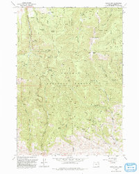
1993 Map of Dooley Mtn
USGS Topo · Published 1993About this map
Whitman National Forest dominates this landscape in the Blue Mountains of Oregon, defined by a complex network of 4WD trails and drainage systems. The terrain is anchored by Dooley Summit and Beaver Mtn, with Bald Ridge carving a distinct line through the northeast quadrant. This map documents a region heavily utilized for its natural resources, evidenced by numerous Gravel Pits, Mine Prospects, and an Open Pit Mine located near Auburn Creek. Water sources are critical in this high-elevation environment, with dozens of named springs such as Moonshine Spring, Bathtub Spring, and Nettle Spring feeding into larger systems like Mill Creek and McClellan Creek. The network of unimproved roads and fire trails suggests a landscape managed for both timber and mineral exploration, while a Radio Facility near the summit marks a point of modern infrastructure amidst the gulches.
Find a feature on this map
40 named features on this map. Tap any name to fly to it.
Don’t see what you’re looking for? This feature index may not catch every label — zoom into the map to look around manually.
Map Details
Editions of this 1993 Dooley Mtn Map
This is the sole edition of this map. No revisions or reprints were ever made.
Other maps of this area

1901 · Baker City
USGS Topo · 1:125,000

1955 · Baker
USGS Topo · 1:250,000

1959 · Baker
USGS Topo · 1:250,000

1964 · Bridgeport
USGS Topo · 1:62,500

1964 · Ironside
USGS Topo · 1:62,500

1967 · Encina
USGS Topo · 1:24,000

1967 · French Gulch
USGS Topo · 1:24,000

1967 · Dooley Mtn
USGS Topo · 1:24,000

1967 · Blue Canyon
USGS Topo · 1:24,000
1967 · Bowen Valley
USGS Topo · 1:24,000