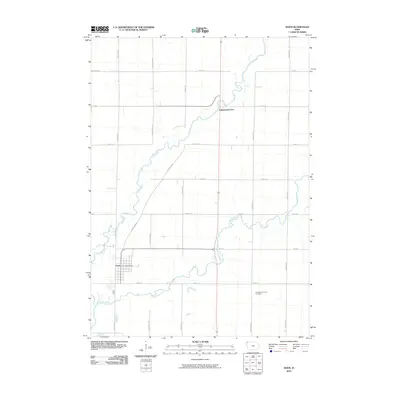
2010 Map of Doon
USGS Topo · Published 2010About this map
The confluence of the Rock River and the Little Rock River dominates this northwest Iowa landscape, where the waterways wind through a strictly organized grid of rural roads and section lines. The settlement of Doon serves as the primary hub, centered near its local rail corridor and the Doon Post Office. This 2010 survey illustrates the persistent agricultural layout of Lyon County, defined by long north-south thoroughfares like Garfield Ave, Goldfinch Ave, and Hickory Ave. Genealogists will find the Garfield Township Cemetery situated southeast of the main town site, providing a specific landmark for family history research. North of the main settlement, the crossing at Lakewood Corner marks an intersection along the river’s path, reflecting the small-scale junction points that characterize the region's rural development.
Find a feature on this map
20 named features on this map. Tap any name to fly to it.
Don’t see what you’re looking for? This feature index may not catch every label — zoom into the map to look around manually.
Map Details
Editions of this 2010 Doon Map
This is the sole edition of this map. No revisions or reprints were ever made.
Other maps of this area

1955 · Sioux Falls
USGS Topo · 1:250,000

1958 · Sioux Falls
USGS Topo · 1:250,000

1964 · Boyden
USGS Topo · 1:24,000

1964 · Hull
USGS Topo · 1:24,000
1968 · Rock Valley
USGS Topo · 1:24,000

1971 · Edna
USGS Topo · 1:24,000

1971 · Lester
USGS Topo · 1:24,000

1971 · George West
USGS Topo · 1:24,000

1971 · Rock Rapids
USGS Topo · 1:24,000

1971 · Doon
USGS Topo · 1:24,000