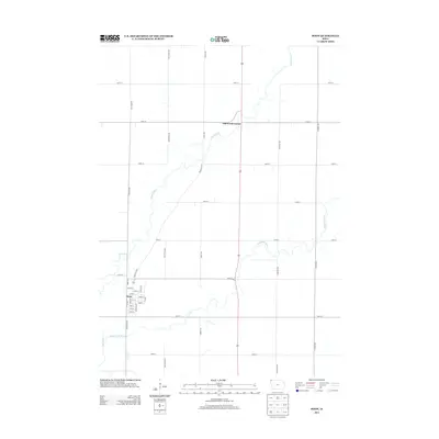
2013 Map of Doon
USGS Topo · Published 2013About this map
The confluence of the Rock River and the Little Rock River defines the landscape of this northwestern Iowa quadrant, where the waters wind through a strictly ordered agricultural grid. The town of Doon serves as the primary settlement, organized around a traditional street plan featuring Main St and numbered avenues such as 1st Ave and 7th Ave. To the north, the small junction at Lakewood Corner sits at the intersection of 210th St and a primary north-south corridor. The map reveals a robust rural infrastructure of named roads like Goldfinch Ave, Grant Ave, and Franklin Blvd, which provide access to the expansive farmsteads that characterize Lyon County. This 2013 survey illustrates the enduring intersection of natural riverine systems with the precise human geometry of the American Midwest.
Find a feature on this map
34 named features on this map. Tap any name to fly to it.
Don’t see what you’re looking for? This feature index may not catch every label — zoom into the map to look around manually.
Map Details
Editions of this 2013 Doon Map
This is the sole edition of this map. No revisions or reprints were ever made.
Other maps of this area
1955 · Sioux Falls
USGS Topo · 1:250,000
1958 · Sioux Falls
USGS Topo · 1:250,000
1964 · Boyden
USGS Topo · 1:24,000
1964 · Hull
USGS Topo · 1:24,000
1968 · Rock Valley
USGS Topo · 1:24,000
1971 · Edna
USGS Topo · 1:24,000
1971 · Lester
USGS Topo · 1:24,000
1971 · George West
USGS Topo · 1:24,000
1971 · Rock Rapids
USGS Topo · 1:24,000
1971 · Doon
USGS Topo · 1:24,000