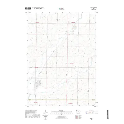
2018 Map of Doon
USGS Topo · Published 2018About this map
The settlement of Doon is established at the confluence where the Little Rock River meets the larger Rock River in Northwest Iowa. This 2018 survey reveals a landscape meticulously organized by the Public Land Survey System, with a rigid grid of gravel and paved roads like Goldfinch Ave and 250th St defining the agricultural sections. The map tracks the meandering paths of these two river systems as they carve through the prairie terrain, contrasting the fluid natural watercourses with the straight-line precision of local infrastructure. To the southeast, the Garfield Township Cem stands as a significant landmark for genealogical research, situated near the intersection of Harrison Ave and Co Hwy A52. The geography captured here reflects the enduring rural character of the region near the Lyon and Sioux County line.
Find a feature on this map
40 named features on this map. Tap any name to fly to it.
Don’t see what you’re looking for? This feature index may not catch every label — zoom into the map to look around manually.
Map Details
Editions of this 2018 Doon Map
This is the sole edition of this map. No revisions or reprints were ever made.
Other maps of this area
1955 · Sioux Falls
USGS Topo · 1:250,000
1958 · Sioux Falls
USGS Topo · 1:250,000
1964 · Boyden
USGS Topo · 1:24,000
1964 · Hull
USGS Topo · 1:24,000
1968 · Rock Valley
USGS Topo · 1:24,000
1971 · Edna
USGS Topo · 1:24,000
1971 · Lester
USGS Topo · 1:24,000
1971 · George West
USGS Topo · 1:24,000
1971 · Rock Rapids
USGS Topo · 1:24,000
1971 · Doon
USGS Topo · 1:24,000