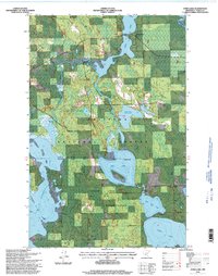
1996 Map of Dora Lake
USGS Topo · Published 1998About this map
The Chippewa National Forest dominates this northern Minnesota landscape, where the Big Fork River flows through a complex network of wetlands and glacial lakes. The settlement of Dora Lake serves as a local hub near the northern reaches of the sheet, while the smaller community of Oslund sits further south between the marshes. This 1990s revision by the Forest Service highlights the intersection of public lands and the Leech Lake Indian Reservation, showing the Administrative Boundary that divides the terrain. Water management and conservation are evident through features like Shogren Dam and the Shogren Dam Impoundment, alongside natural water bodies such as Rice Lake and Sand Lake. For genealogists, the Pine Grove Cemetery provides a specific point of interest within this largely forested and aquatic environment, which is also traversed by a traditional Winter Trail.
Find a feature on this map
22 named features on this map. Tap any name to fly to it.
Don’t see what you’re looking for? This feature index may not catch every label — zoom into the map to look around manually.
Map Details
Editions of this 1996 Dora Lake Map
This is the sole edition of this map. No revisions or reprints were ever made.
Other maps of this area

1918 · Zora
USGS Topo · 1:62,500

1919 · Zora
USGS Topo · 1:62,500

1919 · Gemmell
USGS Topo · 1:62,500

1919 · Max
USGS Topo · 1:62,500

1954 · Bemidji
USGS Topo · 1:250,000

1954 · Hibbing
USGS Topo · 1:250,000

1957 · Bemidji
USGS Topo · 1:250,000

1957 · Hibbing
USGS Topo · 1:250,000

1958 · Bemidji
USGS Topo · 1:250,000

1958 · Hibbing
USGS Topo · 1:250,000