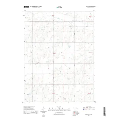
2017 Map of Dorchester SW
USGS Topo · Published 2017About this map
The agricultural landscape of Saline County is defined by a rhythmic section-line road network and a complex drainage system that feeds into the Blue River basin. In this corner of the state, Turkey Creek and Spring Cr wind through the township, carving subtle valleys into the loess plains. For the local historian and genealogist, the map preserves the exact locations of several rural burying grounds, including Gilbert Cem in the north and North Fork Cem at the southern edge, which serve as quiet landmarks for the families who settled this prairie. Significant water management features like Rezabek Reservoir and Swan Creek Reservoir 6-C underscore the transition from early homesteading to modern irrigation and flood control. The grid of county roads, from Co RD G to Co RD N, provides a precise framework for tracing 20th-century property boundaries and rural development.
Find a feature on this map
26 named features on this map. Tap any name to fly to it.
Don’t see what you’re looking for? This feature index may not catch every label — zoom into the map to look around manually.
Map Details
Editions of this 2017 Dorchester SW Map
This is the sole edition of this map. No revisions or reprints were ever made.
Other maps of this area
1935 · Dorchester
USGS Topo · 1:48,000
1940 · Dorchester
USGS Topo · 1:62,500
1955 · Lincoln
USGS Topo · 1:250,000
1957 · Lincoln
USGS Topo · 1:250,000
1958 · Lincoln
USGS Topo · 1:250,000
1961 · Tobias
USGS Topo · 1:24,000
1961 · Western
USGS Topo · 1:24,000
1961 · Swanton
USGS Topo · 1:24,000
1964 · Pleasant Hill
USGS Topo · 1:24,000
1964 · Dorchester
USGS Topo · 1:24,000