
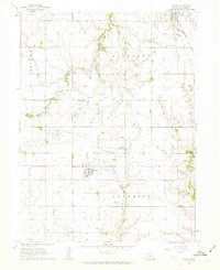
1961 Map of Tobias
USGS Topo · Published 1963About this map
The village of Tobias stands as a central hub in this agricultural landscape, situated at the intersection of a grid-based township system and the Chicago Burlington and Quincy railroad line. The map captures the organized rural life of Saline County in the early 1960s, where small-scale institutions like Ward Sch and Zion Sch remained important community markers alongside their respective burial grounds, such as the Zion Sch Cem. The terrain is defined by the winding paths of Swan Creek and Spring Creek, which cut through the level plains and influenced the placement of farmsteads and field lines. Regional identity is further established through the township divisions of Atlanta, Glengary, Franklin, and Olive, illustrating the precise surveying that governed Nebraska's settlement patterns during this era.
Find a feature on this map
17 named features on this map. Tap any name to fly to it.
Don’t see what you’re looking for? This feature index may not catch every label — zoom into the map to look around manually.
Map Details
Editions of this 1961 Tobias Map
This is the sole edition of this map. No revisions or reprints were ever made.
Other maps of this area

1935 · Dorchester
USGS Topo · 1:48,000

1940 · Dorchester
USGS Topo · 1:62,500

1955 · Lincoln
USGS Topo · 1:250,000

1957 · Lincoln
USGS Topo · 1:250,000

1958 · Lincoln
USGS Topo · 1:250,000

1960 · Western SW
USGS Topo · 1:24,000

1960 · Tobias SW
USGS Topo · 1:24,000

1960 · Daykin
USGS Topo · 1:24,000
1961 · Ohiowa
USGS Topo · 1:24,000

1961 · Western
USGS Topo · 1:24,000