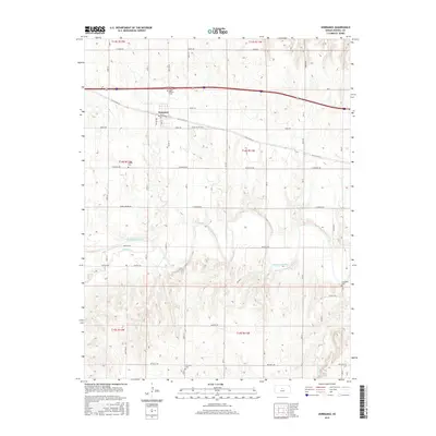
2015 Map of Dorrance
USGS Topo · Published 2015About this map
Dorrance sits as a central hub on this Russell County landscape, bounded to the south by the meandering course of the Smoky Hill River. The settlement pattern reflects the enduring agricultural layout of the region, where a dense network of section-line roads like Fairfield Rd and Lincoln Rd connect outlying homesteads to the town core. Transportation history is deeply visible here, with both Old US Hwy 40 and Old 40 Rd tracing the legacy of early transcontinental travel across the Kansas plains. For genealogists, the map is particularly valuable for its documentation of four distinct burial grounds: Saint Joseph Cem, Colony Cem, Immanuel Cem, and Schreiner Cem, each marking a piece of the area's local heritage and settlement history. The terrain transitions from the upland flats near Homer Rd down to the river valley carved by Beaver Cr and Coal Cr.
Find a feature on this map
30 named features on this map. Tap any name to fly to it.
Don’t see what you’re looking for? This feature index may not catch every label — zoom into the map to look around manually.
Map Details
Editions of this 2015 Dorrance Map
This is the sole edition of this map. No revisions or reprints were ever made.
Other maps of this area

1894 · Ellsworth
USGS Topo · 1:125,000

1896 · Russell
USGS Topo · 1:125,000

1955 · Great Bend
USGS Topo · 1:250,000

1956 · Wilson
USGS Topo · 1:24,000

1956 · Dorrance
USGS Topo · 1:24,000

1956 · Dorrance SW
USGS Topo · 1:24,000

1957 · Great Bend
USGS Topo · 1:250,000

1958 · Great Bend
USGS Topo · 1:250,000
1964 · Wilson NW
USGS Topo · 1:24,000
1964 · Holyrood NW
USGS Topo · 1:24,000