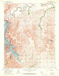
1964 Map of Wilson NW
USGS Topo · Published 1964About this map
Wilson Reservoir and its newly forming shoreline dominate this 1964 survey, capturing a landscape in the midst of massive change. Blue hatching across the terrain indicates areas slated to be submerged by the rising waters, a crucial detail for researchers tracking land ownership and topographical shifts before the basin filled. The Wilson Dam stands as the primary engineering feature controlling the flow of the Saline River, which meanders through the townships of Pleasant and Highland. Away from the inundation zone, the map documents the rural infrastructure of the era, including a gaging station along the river and scattered industrial marks such as several quarries, a gravel pit, and a drill hole. These labels provide evidence of the local mineral extraction and utility networks that supported the region as the reservoir altered the natural course of Hell Creek and its surroundings.
Find a feature on this map
15 named features on this map. Tap any name to fly to it.
Don’t see what you’re looking for? This feature index may not catch every label — zoom into the map to look around manually.
Map Details
Editions of this 1964 Wilson NW Map
2 editions found
Other maps of this area

1894 · Ellsworth
USGS Topo · 1:125,000

1894 · Beloit
USGS Topo · 1:125,000

1896 · Osborne
USGS Topo · 1:125,000

1896 · Russell
USGS Topo · 1:125,000

1955 · Great Bend
USGS Topo · 1:250,000

1955 · Beloit
USGS Topo · 1:250,000

1956 · Wilson
USGS Topo · 1:24,000

1956 · Dorrance
USGS Topo · 1:24,000

1957 · Great Bend
USGS Topo · 1:250,000

1957 · Black Wolf
USGS Topo · 1:24,000