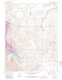
1964 Map of Wilson NW
USGS Topo · Published 1980About this map
The Saline River winds through the northern landscape of Lincoln County, defining the drainage patterns for Pleasant and Fairview. The construction of the Wilson Dam significantly altered this region, creating a large reservoir that serves as the centerpiece for the Wilson State Park and the adjacent Wilson State Wildlife Area. These recreational and conservation zones, including the Sylvan Public Use Area and Otoe Public Use Area, occupy the southwestern portion of the sheet where the river was impounded.
Find a feature on this map
22 named features on this map. Tap any name to fly to it.
Don’t see what you’re looking for? This feature index may not catch every label — zoom into the map to look around manually.
Map Details
Editions of this 1964 Wilson NW Map
2 editions found
Other maps of this area

1894 · Ellsworth
USGS Topo · 1:125,000

1894 · Beloit
USGS Topo · 1:125,000

1896 · Osborne
USGS Topo · 1:125,000

1896 · Russell
USGS Topo · 1:125,000

1955 · Great Bend
USGS Topo · 1:250,000

1955 · Beloit
USGS Topo · 1:250,000

1956 · Wilson
USGS Topo · 1:24,000

1956 · Dorrance
USGS Topo · 1:24,000

1957 · Great Bend
USGS Topo · 1:250,000

1957 · Black Wolf
USGS Topo · 1:24,000