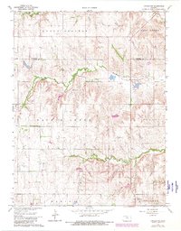
1968 Map of Lincoln NW
USGS Topo · Published 1980About this map
Round Springs and the surrounding townships of Scott, Marion, and Beaver define this portion of the Kansas landscape, where the drainage systems of Salt Creek and Rattlesnake Creek carve through the terrain. The map reveals a rural economy based on both agriculture and local resource extraction, as evidenced by several Gravel Pits and a Quarry located near the watercourses. For genealogists, the placement of Prairie Grove Cem in the southwestern quadrant provides a vital landmark for tracing family histories in this part of Lincoln County. The convergence of Battle Creek and its namesake township highlights the early naming conventions of the region, while the boundary line between Mitchell Co and Lincoln Co marks the northern extent of this 1968 survey.
Find a feature on this map
13 named features on this map. Tap any name to fly to it.
Don’t see what you’re looking for? This feature index may not catch every label — zoom into the map to look around manually.
Map Details
Editions of this 1968 Lincoln NW Map
2 editions found
Other maps of this area

1894 · Beloit
USGS Topo · 1:125,000

1955 · Beloit
USGS Topo · 1:250,000

1959 · Beloit
USGS Topo · 1:250,000

1962 · Vesper
USGS Topo · 1:24,000

1962 · Lincoln
USGS Topo · 1:24,000
1963 · Shady Bend
USGS Topo · 1:24,000
1964 · Barnard
USGS Topo · 1:24,000
1964 · Beloit SE
USGS Topo · 1:24,000

1968 · Beloit SW
USGS Topo · 1:24,000

1968 · Lincoln NW
USGS Topo · 1:24,000