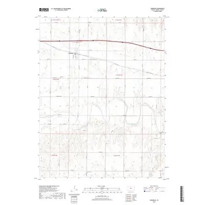
2018 Map of Dorrance
USGS Topo · Published 2018About this map
Dorrance serves as the central hub of this Russell County landscape, situated where the historic corridor of Old US Hwy 40 and Interstate 70 cross the Kansas prairie. The town's grid is bounded by Taylor Ave and Water St, preserving the layout of a traditional plains settlement. To the south, the terrain is defined by the winding course of the Smoky Hill River, which is joined by Beaver Cr and Coal Cr. This river valley provides a sharp contrast to the upland section lines that organize the surrounding farmland. Genealogists and local historians will find several rural burial sites scattered across the townships, including Saint Joseph Cem near the town center, and more remote locations like Colony Cem, Immanuel Cem, and Schreiner Cem, which mark the presence of early family farmsteads and rural congregations.
Find a feature on this map
47 named features on this map. Tap any name to fly to it.
Don’t see what you’re looking for? This feature index may not catch every label — zoom into the map to look around manually.
Map Details
Editions of this 2018 Dorrance Map
This is the sole edition of this map. No revisions or reprints were ever made.
Other maps of this area

1894 · Ellsworth
USGS Topo · 1:125,000

1896 · Russell
USGS Topo · 1:125,000

1955 · Great Bend
USGS Topo · 1:250,000

1956 · Wilson
USGS Topo · 1:24,000

1956 · Dorrance
USGS Topo · 1:24,000

1956 · Dorrance SW
USGS Topo · 1:24,000

1957 · Great Bend
USGS Topo · 1:250,000

1958 · Great Bend
USGS Topo · 1:250,000
1964 · Wilson NW
USGS Topo · 1:24,000
1964 · Holyrood NW
USGS Topo · 1:24,000