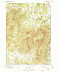
1967 Map of Dorset
USGS Topo · Published 1972About this map
Dorset Mountain dominates the center of this terrain, where the rugged peaks of the Green Mountains define the industrial and agricultural patterns of the late 1960s. The eastern slopes are marked by numerous quarries and a distinctive Incline RR near Freedleyville, reflecting the region's historic marble extraction industry. The landscape transitions from the high elevations of Dorset Peak and Netop Mtn down to the valley floors of the Mettawee River and Otter Creek.
Find a feature on this map
45 named features on this map. Tap any name to fly to it.
Don’t see what you’re looking for? This feature index may not catch every label — zoom into the map to look around manually.
Map Details
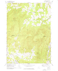
Editions of this 1967 Dorset Map
2 editions found
Other maps of this area

1893 · Wallingford
USGS Topo · 1:62,500

1894 · Londonderry
USGS Topo · 1:62,500

1894 · Pawlet
USGS Topo · 1:62,500

1894 · Equinox
USGS Topo · 1:62,500

1896 · Equinox
USGS Topo · 1:62,500

1897 · Pawlet
USGS Topo · 1:62,500

1899 · Londonderry
USGS Topo · 1:62,500

1900 · Equinox
USGS Topo · 1:62,500

1903 · Mettawee
USGS Topo · 1:125,000

1950 · Glens Falls
USGS Topo · 1:250,000