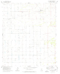
1974 Map of Dos Cabezas SW
USGS Topo · Published 1976About this map
Water management and utility infrastructure dominate this corner of Cochise County, where the landscape is defined by a systematic grid of section lines and numerous individual wells. At the center of the industrial footprint sits a Compressor Station, serving as a hub for the various Pipelines that traverse the area. The natural drainage of O B Draw cuts through the northern sections, providing the primary topographical relief in an otherwise strictly managed terrain.
Find a feature on this map
9 named features on this map. Tap any name to fly to it.
Don’t see what you’re looking for? This feature index may not catch every label — zoom into the map to look around manually.
Map Details
Editions of this 1974 Dos Cabezas SW Map
This is the sole edition of this map. No revisions or reprints were ever made.
Other maps of this area

1916 · Pearce
USGS Topo · 1:125,000

1922 · Willcox
USGS Topo · 1:125,000

1926 · Light
USGS Topo · 1:62,500

1926 · Courtland
USGS Topo · 1:62,500

1943 · Dos Cabezas
USGS Topo · 1:62,500

1943 · Cochise
USGS Topo · 1:62,500

1954 · Silver City
USGS Topo · 1:250,000

1955 · Douglas
USGS Topo · 1:250,000

1957 · Dos Cabezas
USGS Topo · 1:62,500

1958 · Silver City
USGS Topo · 1:250,000