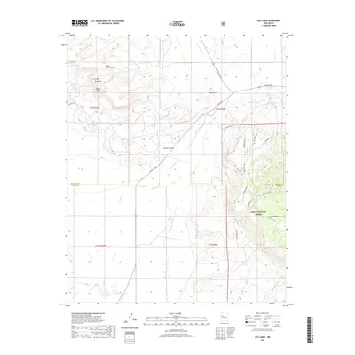
2020 Map of Dos Lomas
USGS Topo · Published 2020About this map
El Puertecito sits at a crossroads in this high-desert landscape, where the northern expanse of the Cibola National Forest meets the boundary between McKinley and Cibola counties. The terrain is defined by prominent basaltic and sandstone formations, including the distinct Round Butte and the broad Mesa Montanosa. To the south, La Jara Mesa overlooks the drainage of San Mateo Creek, a landscape carved by seasonal waterflows like the Arroyo del Puerto. The road network, including San Mateo Rd and Ambrosia Lake Rd, reflects the region's connection to historic ranching and mining corridors. Significant land features like Flat Mesa Dos Lomas and the descriptively named Poison Canyon provide specific landmarks for those studying the physical history and land use patterns of this New Mexico quadrangle.
Find a feature on this map
24 named features on this map. Tap any name to fly to it.
Don’t see what you’re looking for? This feature index may not catch every label — zoom into the map to look around manually.
Map Details
Editions of this 2020 Dos Lomas Map
This is the sole edition of this map. No revisions or reprints were ever made.
Other maps of this area

1883 · Mt. Taylor
USGS Topo · 1:250,000

1886 · Mt. Taylor
USGS Topo · 1:250,000

1892 · Mt. Taylor
USGS Topo · 1:250,000

1899 · Mt. Taylor
USGS Topo · 1:250,000

1957 · Lobo Springs
USGS Topo · 1:24,000

1957 · Ambrosia Lake
USGS Topo · 1:24,000

1957 · Dos Lomas
USGS Topo · 1:24,000

1957 · Bluewater
USGS Topo · 1:24,000

1957 · Goat Mountain
USGS Topo · 1:24,000
1957 · Grants
USGS Topo · 1:24,000