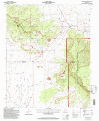
1995 Map of Dos Lomas
USGS Topo · Published 1997About this map
The high desert landscape of McKinley and Cibola Counties is defined by a dense concentration of uranium and mineral extraction sites during the late twentieth century. Industrial operations like the Anaconda Section Nine Strip Mine, Zia Mines, and Poison Canyon Mine dominate the central basin, highlighting the region's importance to the mining economy. This network of industrial development is set against the sprawling Cibola National Forest and Navajo Indian Land, illustrating the proximity of commercial extraction to protected and tribal territories.
Find a feature on this map
27 named features on this map. Tap any name to fly to it.
Don’t see what you’re looking for? This feature index may not catch every label — zoom into the map to look around manually.
Map Details
Editions of this 1995 Dos Lomas Map
This is the sole edition of this map. No revisions or reprints were ever made.
Other maps of this area

1883 · Mt. Taylor
USGS Topo · 1:250,000

1886 · Mt. Taylor
USGS Topo · 1:250,000

1892 · Mt. Taylor
USGS Topo · 1:250,000

1899 · Mt. Taylor
USGS Topo · 1:250,000

1957 · Lobo Springs
USGS Topo · 1:24,000

1957 · Ambrosia Lake
USGS Topo · 1:24,000

1957 · Dos Lomas
USGS Topo · 1:24,000

1957 · Bluewater
USGS Topo · 1:24,000

1957 · Goat Mountain
USGS Topo · 1:24,000
1957 · Grants
USGS Topo · 1:24,000