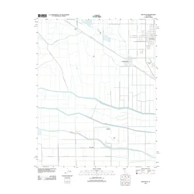
2012 Map of Dos Palos
USGS Topo · Published 2012About this map
The town of Dos Palos serves as the focal point of this agricultural landscape in Merced County, where an intricate irrigation network supports the valley's productivity. The map highlights the engineered waterways essential to the region, including the massive Delta-Mendota Canal and the local Colony Branch Number Two Canal. The grid of rural roads, such as Santa Fe Grade and Mallard Rd, connects outlying settlements and agricultural operations like Gable Ranch and Brito to the central hub. To the south, the settlement of Oro Loma and the historic Eagle Field landing strip stand out as notable landmarks within the flat, expansive terrain. The layout of South Dos Palos and the proximity of the Dos Palos Airport reflect the region's mid-century development and its continued reliance on a mix of aviation and ground-based transit to move people and goods across the Central Valley.
Find a feature on this map
43 named features on this map. Tap any name to fly to it.
Don’t see what you’re looking for? This feature index may not catch every label — zoom into the map to look around manually.
Map Details
Editions of this 2012 Dos Palos Map
This is the sole edition of this map. No revisions or reprints were ever made.
Other maps of this area

1913 · Panoche
USGS Topo · 1:125,000

1916 · Santa Rita Bridge
USGS Topo · 1:24,000

1916 · Delta Ranch
USGS Topo · 1:24,000

1920 · Santa Rita Bridge
USGS Topo · 1:31,680

1921 · Los Banos
USGS Topo · 1:31,680

1921 · Laguna Seca Ranch
USGS Topo · 1:31,680

1922 · Oxalis
USGS Topo · 1:31,680

1922 · Santa Rita Bridge
USGS Topo · 1:31,680

1922 · Charleston School
USGS Topo · 1:31,680

1922 · Dos Palos
USGS Topo · 1:31,680