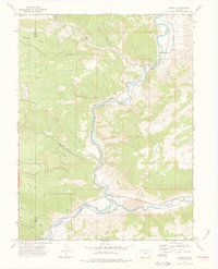
1974 Map of Dotsero
USGS Topo · Published 1977About this map
Dotsero sits at a critical geographic junction in the mid-1970s, marking the point where the Colorado River and the Eagle River converge. The landscape is dominated by complex geological formations, most notably the Dotsero Crater and several unnamed mines that indicate the area's mineral interest. The Denver and Rio Grande Western railroad tracks parallel the river's winding course through deep canyons, illustrating the era's reliance on rail transport to navigate this formidable terrain. In the surrounding heights, old routes like the Coffee Pot Road and trails across Onion Ridge provide access to cattle grazing land and drainage basins including Deep Creek and Sweetwater Creek. This survey captures the region just as it remained a remote but vital transport corridor for Western Colorado, characterized by steep elevations such as Blowout Hill and the dramatic gap at Hells Gate.
Find a feature on this map
20 named features on this map. Tap any name to fly to it.
Don’t see what you’re looking for? This feature index may not catch every label — zoom into the map to look around manually.
Map Details
Editions of this 1974 Dotsero Map
3 editions found
Other maps of this area

1927 · Glenwood Springs
USGS Topo · 1:125,000

1930 · Glenwood Springs
USGS Topo · 1:125,000

1957 · Leadville
USGS Topo · 1:250,000

1959 · Leadville
USGS Topo · 1:250,000

1960 · Leadville
USGS Topo · 1:250,000

1961 · Cottonwood Pass
USGS Topo · 1:24,000

1961 · Shoshone
USGS Topo · 1:24,000

1962 · Leadville
USGS Topo · 1:250,000

1962 · Gypsum
USGS Topo · 1:24,000
1962 · Suicide Mountain
USGS Topo · 1:24,000