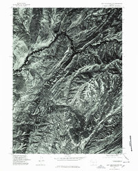
1975 Map of Doty Mountain NW
USGS Topo · Published 1978About this map
Doty Mountain and the surrounding high desert of Carbon County are captured in this mid-1970s orthophotoquad, which utilizes aerial photography to document the complex erosion patterns and drainage systems of the Wyoming landscape. The imagery highlights the stark geological formations of China Butte and the winding course of Dry Creek as it carves through the arid terrain. Unlike standard topographic maps, this orthophotograph provides a direct visual record of the ground surface, revealing the density of sagebrush and the subtle cattle trails or ranching tracks that are often omitted from traditional line-drawn maps. It serves as a raw visual baseline for the region before modern energy development or land-use changes altered the surface of these remote basins.
Find a feature on this map
3 named features on this map. Tap any name to fly to it.
Don’t see what you’re looking for? This feature index may not catch every label — zoom into the map to look around manually.
Map Details
Editions of this 1975 Doty Mountain NW Map
This is the sole edition of this map. No revisions or reprints were ever made.
Other maps of this area

1954 · Rawlins
USGS Topo · 1:250,000

1957 · Doty Mountain
USGS Topo · 1:62,500

1958 · Rawlins
USGS Topo · 1:250,000

1962 · Rawlins
USGS Topo · 1:250,000

1966 · Seaverson Reservoir
USGS Topo · 1:24,000

1966 · High Point
USGS Topo · 1:24,000

1966 · Fillmore Ranch
USGS Topo · 1:24,000

1967 · Rawlins
USGS Topo · 1:250,000

1970 · Mexican Flats
USGS Topo · 1:24,000

1970 · Duck Lake
USGS Topo · 1:24,000