
1966 Map of High Point
USGS Topo · Published 1969About this map
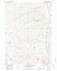
The Continental Divide snakes across this high-altitude landscape in Carbon County, defining the hydrologic split of the American West. Mapped in the mid-1960s, this area is characterized by drainage patterns like Horse Pasture Draw and Standard Draw that underscore the arid, open-range character of the Wyoming high desert. The terrain is dominated by significant elevations such as High Point and the isolated rise of Sugarloaf, providing a detailed look at the land's natural contours before modern industrial shifts. Evidence of resource exploration is scattered throughout the region, indicated by several Drill Hole markers and a Prospect near Coal Bank. These technical labels, alongside water sources like Coal Bank Spring, reflect the vital importance of geology and limited water in the development of the Wyoming interior.
Find a feature on this map
14 named features on this map. Tap any name to fly to it.
Don’t see what you’re looking for? This feature index may not catch every label — zoom into the map to look around manually.
Map Details
Editions of this 1966 High Point Map
2 editions found
Other maps of this area

1954 · Rawlins
USGS Topo · 1:250,000

1957 · Doty Mountain
USGS Topo · 1:62,500

1958 · Rawlins
USGS Topo · 1:250,000

1962 · Rawlins
USGS Topo · 1:250,000

1966 · Creston Junction
USGS Topo · 1:24,000

1966 · Wamsutter
USGS Topo · 1:24,000

1966 · Seaverson Reservoir
USGS Topo · 1:24,000

1966 · Creston
USGS Topo · 1:24,000

1966 · Eightmile Lake
USGS Topo · 1:24,000

1967 · Rawlins
USGS Topo · 1:250,000