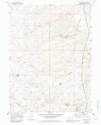
1966 Map of High Point
USGS Topo · Published 1981About this map
The Continental Divide winds across this high-altitude landscape in Carbon County, defining a rugged watershed where drainage systems like Coal Bank Wash and Coal Bank Draw begin their descent. This 1960s survey, updated in the early 1980s, reveals a terrain primarily shaped by resource exploration and natural drainage. A prominent peak at High Point overlooks the surrounding basins, where a series of Drill Hole locations and a Prospect indicate the region's mineral interests.
Find a feature on this map
16 named features on this map. Tap any name to fly to it.
Don’t see what you’re looking for? This feature index may not catch every label — zoom into the map to look around manually.
Map Details
Editions of this 1966 High Point Map
2 editions found
Other maps of this area

1954 · Rawlins
USGS Topo · 1:250,000

1957 · Doty Mountain
USGS Topo · 1:62,500

1958 · Rawlins
USGS Topo · 1:250,000

1962 · Rawlins
USGS Topo · 1:250,000

1966 · Creston Junction
USGS Topo · 1:24,000

1966 · Wamsutter
USGS Topo · 1:24,000

1966 · Seaverson Reservoir
USGS Topo · 1:24,000

1966 · Creston
USGS Topo · 1:24,000

1966 · High Point
USGS Topo · 1:24,000

1966 · Eightmile Lake
USGS Topo · 1:24,000