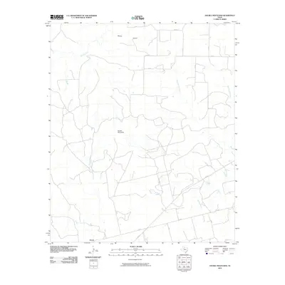
2010 Map of Double Mountains
USGS Topo · Published 2010About this map
The Double Mountains dominate the central landscape of this Stonewall County quadrangle, rising above a network of drainages that feed the regional salt forks. In the southern reach of the map, the small settlement of Dorras sits near the intersection of FM 610 and C R 452, serving as a focal point for the surrounding ranch and farm land. The terrain is deeply incised by seasonal waterways including Stinking Creek in the north and the meandering Nicholson Creek which flows toward the south.
Find a feature on this map
22 named features on this map. Tap any name to fly to it.
Don’t see what you’re looking for? This feature index may not catch every label — zoom into the map to look around manually.
Map Details
Editions of this 2010 Double Mountains Map
This is the sole edition of this map. No revisions or reprints were ever made.
Other maps of this area

1893 · Roby
USGS Topo · 1:125,000

1926 · Snyder 1-a
USGS Topo · 1:48,000

1926 · Roby 2-b
USGS Topo · 1:48,000

1931 · Rotan
USGS Topo · 1:62,500

1932 · Camp Springs
USGS Topo · 1:62,500

1954 · Lubbock
USGS Topo · 1:250,000

1954 · Big Spring
USGS Topo · 1:250,000

1958 · Big Spring
USGS Topo · 1:250,000

1968 · Double Mountains
USGS Topo · 1:24,000
1968 · Coon Hollow
USGS Topo · 1:24,000