
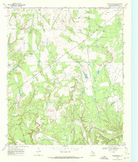
1968 Map of Double Mountains
USGS Topo · Published 1972About this map
The Double Mountains dominate the horizon of this Stonewall County landscape, serving as a primary topographic landmark in the region during the late 1960s. This survey, based on 1966 aerial photography, reveals a remote ranching and energy-producing environment defined by intermittent waterways and rising industrial infrastructure. The drainage system is characterized by the Salt Fork and winding tributaries like Stinking Creek, Wildcat Canyon, and Nicholson Creek. Evidence of mid-century resource extraction is prominent throughout the terrain, with numerous Oil Wells and a significant Pipeline cutting across the southern portion of the quadrangle. Aside from these industrial markings and a few remote Drill Holes, the landscape remains largely open, marked by a natural Spring and the seasonal flow of Long Creek.
Find a feature on this map
11 named features on this map. Tap any name to fly to it.
Don’t see what you’re looking for? This feature index may not catch every label — zoom into the map to look around manually.
Map Details
Editions of this 1968 Double Mountains Map
This is the sole edition of this map. No revisions or reprints were ever made.
Other maps of this area

1893 · Roby
USGS Topo · 1:125,000

1926 · Snyder 1-a
USGS Topo · 1:48,000

1926 · Roby 2-b
USGS Topo · 1:48,000

1931 · Rotan
USGS Topo · 1:62,500

1932 · Camp Springs
USGS Topo · 1:62,500

1954 · Lubbock
USGS Topo · 1:250,000

1954 · Big Spring
USGS Topo · 1:250,000

1958 · Big Spring
USGS Topo · 1:250,000
1968 · Coon Hollow
USGS Topo · 1:24,000

1968 · Peacock
USGS Topo · 1:24,000