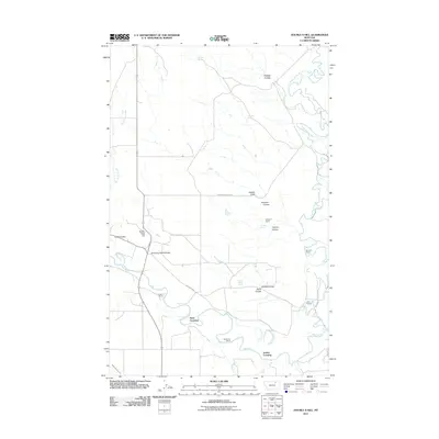
2011 Map of Double S Hill
USGS Topo · Published 2011About this map
The Milk River and Frenchman Creek converge in this section of north-central Montana, defining a landscape of wide river bottoms and seasonal drainage paths. Local ranching history is anchored by family-named holdings such as Galiger's Ranch, Whitford's Ranch, and Hunter's Ranch, which sit among the many named coulees that channel runoff toward the river. The presence of Bone Crossing and Jordan Crossing suggests historical points of transit across the water, while the Nelson South Canal indicates the importance of irrigation and water management for the region's agricultural viability. High points like Double S Hill and Turkey Track Hill overlook a network of rural roads, including Milk River Rd and Frenchman Creek Rd. The terrain is further marked by unique water sources like Negro Jakes Spring and Wrights Spring, essential landmarks in a region defined by its hydrology and livestock operations.
Find a feature on this map
24 named features on this map. Tap any name to fly to it.
Don’t see what you’re looking for? This feature index may not catch every label — zoom into the map to look around manually.
Map Details
Editions of this 2011 Double S Hill Map
This is the sole edition of this map. No revisions or reprints were ever made.
Other maps of this area

1905 · Saco Special
USGS Topo · 1:62,500

1906 · Hinsdale Special Map
USGS Topo · 1:62,500

1954 · Glasgow
USGS Topo · 1:250,000

1957 · Glasgow
USGS Topo · 1:250,000

1958 · Glasgow
USGS Topo · 1:250,000

1984 · Cole
USGS Topo · 1:24,000

1984 · Bjornberg Bridge
USGS Topo · 1:24,000
1984 · Robinson Ranch
USGS Topo · 1:24,000

1984 · Double S Hill
USGS Topo · 1:24,000

1984 · Forks
USGS Topo · 1:24,000