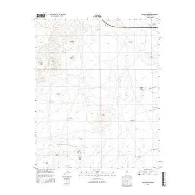
2013 Map of Dough Mountain
USGS Topo · Published 2013About this map
Mesita sits at the northern edge of this high-desert landscape, where the Rio San Jose cuts through the terrain near Dirty Point. The 2013 survey illustrates a region defined by complex geological formations and livestock infrastructure, including Windmill Number 9 and the Kose Sheep Camp. The volcanic history of the area is evident through prominent landmarks like Lava Butte, South Lava Butte, and Dough Mountain, while numerous water-management features such as Dough Mountain Lake and the South Passage Reservoirs reflect the necessity of managing runoff in the arid environment. A network of tribal and local routes, including Indian Service Road 544 and Indian Service Road 545, provides access across the mesas and washes. These roads connect the higher elevations of Crow Mesa and South Point Mesa to the lower basins of the Big Sandy Wash.
Find a feature on this map
33 named features on this map. Tap any name to fly to it.
Don’t see what you’re looking for? This feature index may not catch every label — zoom into the map to look around manually.
Map Details
Editions of this 2013 Dough Mountain Map
This is the sole edition of this map. No revisions or reprints were ever made.
Other maps of this area

1883 · Mt. Taylor
USGS Topo · 1:250,000

1886 · Mt. Taylor
USGS Topo · 1:250,000

1892 · Mt. Taylor
USGS Topo · 1:250,000

1899 · Mt. Taylor
USGS Topo · 1:250,000

1917 · Cerro Verde
USGS Topo · 1:125,000

1954 · Socorro
USGS Topo · 1:250,000

1956 · South Garcia
USGS Topo · 1:62,500

1957 · Laguna
USGS Topo · 1:24,000
1957 · Mesa Gigante
USGS Topo · 1:24,000

1957 · Mesita
USGS Topo · 1:24,000